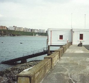
Port Erin tide gauge site
The tide gauge equipment is situated in Port Erin lifeboat station and the pressure points are mounted close to the end of the
lifeboat slipway.
Click here
to see a map of the site in a separate window.
Tide gauge location
The equipment is housed in a heated GRP cabinet within the lifeboat station with the full tide and mid-tide pressure points being mounted on steelwork attached to a concrete leg of the slipway. All three pressure lines are monitored by the POL data logger.
 The tide gauge is levelled to the tide gauge bench mark support by POL auxiliary marks.
External users
Sea level pressures and/or elevations from this site are supplied to the following authority:
- Isle of Man Meteorological Office
Site history
1992 – DATARING system installed with two full-tide bubblers
1995 – Tide gauge removed during refurbishment of the lifeboat station
1998 – DATARING system installed with two full-tide and mid-tide bubblers
2001 – POL data logger installed
| Location | |
| Latitude | 54° 5.113'N |
| Longitude | 4° 46.083'W |
| Grid ref | SC 1904 6902 |
| Earliest data | 1992 |
| Tidal levels | |
| HAT | 5.89 m |
| LAT | -0.24 m |
| MHWS | 5.28 m |
| MHWN | 4.20 m |
| MLWN | 1.54 m |
| MLWS | 0.41 m |
| H for 2024 | 5.85 m |
| L for 2024 | -0.24 m |
| H for 2025 | 5.76 m |
| L for 2025 | -0.16 m |
| MSR | 4.87 m |
| MNR | 2.66 m |
Abbreviations
HAT – highest astronomical tide
LAT – lowest astronomical tide
MHWS – mean high water springs
MHWN – mean high water neaps
MLWN – mean low water neaps
MLWS – mean low water springs
H – highest for year
L – lowest for year
MSR – mean spring range
MNR – mean neap range
Measurement devices
Tide gauge systemsFull-tide bubbler
Half-tide bubbler
Direct pressure transducer
Tide gauges
Ott pneumatic gauge
Munro float gauge
Wellhead float gauge
Lea float gauge
Instruments
DATARING logger
Datum probe